
CA Truck Network
The color-coded "California Truck Network" for State highways is the official government source for truck route information. There are many private truck route guides, e.g., the Rand McNally Motor Carrier Atlas and various GPS systems. However, the accuracy of those private guides cannot be guaranteed, and must be verified by consulting the official "Caltrans Truck Network," which could be found in QuickMap under the Commercial Vehicle Options. Where inaccessibility to internet is expected during travel, one may choose to print PDF versions of the Caltrans Truck Network maps, accessible by clicking on the number 1-12 following District Maps (PDF) below. The table at the bottom of the page shows which color routes on the map your truck may legally travel on.
- QuickMap - California Truck Network under Commercial Vehicles Option
- Truck Map Legend (PDF) - truck lengths & routes
- 3-Step Quick Guide - determine which routes your truck may legally travel on
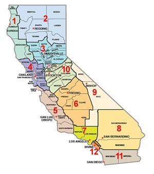
District Maps (PDF): 1, 2, 3, 4, 5, 6, 7, 8, 9, 10, 11, 12
| ROUTE COLORS | ROUTE TYPE | SIGNS | "GREEN" STAA TRUCKS | "BLACK" CALIFORNIA LEGAL TRUCKS | |
|---|---|---|---|---|---|
Green |
Primarily interstates |
None | YES | YES | |
Blue |
State routes |  |
YES | YES | |
Black-Dashed |
State routes | Usually none | NO | YES | |
Yellow (KPRA Advisory Routes) |
State routes |  |
NO |
YES -- However, we advise you not to travel on an advisory route unless your KPRA is no more than the posted length, which is 30 feet on most routes. |
|
Red |
Varies | Example: |
The restriction may or may not apply to you. Read the restriction on the map to determine whether it applies. See also the Special Route Restrictions. |
||