All-in-one version
Director’s Message
Characteristically, Caltrans rises to the latest challenge

Tony Tavares
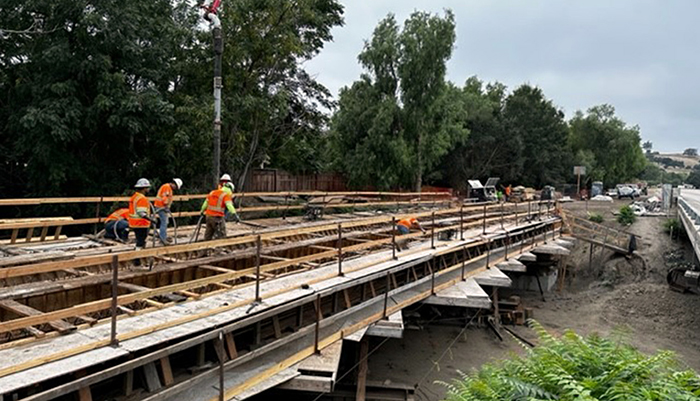
During the early morning of Nov. 11, a fire erupted underneath Interstate 10 in downtown Los Angeles. CAL FIRE determined that an arsonist had caused the blaze, which forced the closure of a two-mile stretch of a heavily used (a daily average of 300,000 vehicles) urban roadway.
More than 100 columns supporting this segment sustained damage, and repair work appeared as a daunting task that could take months to complete. Fortunately, that grim forecast soon brightened considerably. Working with subcontractors Security Paving Co. of Westlake Village and Griffith Co. of Brea, along with federal, state and local partners, Caltrans orchestrated Interstate 10’s full reopening eight days after the fire.
On Nov. 19, Governor Gavin Newsom announced that Caltrans would begin opening Interstate 10 that night and have the freeway fully open with all five lanes in each direction available the following morning.
“What began as months has turned into days — before Angelenos hit the road on Monday, we’re opening the 10 back up,” the governor told reporters. “Thanks to the tireless work of Caltrans and union construction crews and with help from our partners … the 10’s expedited repair is proof and a point of pride that here in California, we deliver.”
“The work that happened here is extraordinary,” said Vice President Kamala Harris, a former U.S. senator from the Golden State. “It was possible with the will and ambition of the workers on the ground, and their commitment as public servants and as union members to get this done and deliver for the people of Los Angeles.”
Steps that were taken to produce this sterling result included:
- Caltrans emergency contractors cleared all hazardous materials from the repair site.
- More than 250 people worked at the jobsite on 12-hour shifts, 24 hours a day, every day. They safely removed approximately 264,000 cubic feet of hazardous material and debris — enough to roughly fill four Olympic-size pools. More than two dozen burned vehicles were removed.
- Contractors brought in extra 100-ton hydraulic jacks to install temporary supports, called shoring, next to damaged concrete pillars under the elevated freeway.
- California secured $3 million in “quick release” emergency funding from the Federal Highway Administration to offset initial costs.
- While I-10 was closed between Alameda Street and the East Los Angeles interchange, workers took advantage of the closure to repair concrete in freeway lanes.
- Security provided around-the-clock coverage at the jobsite to minimize the economic impact on nearby businesses.
Every now and then, Caltrans, which oversees the maintenance of federal interstates in California including what’s known locally as “The 10,” gets thrust into the news when a high-profile roadway shuts down unexpectedly and the public – represented by the media – wants to know how soon things will get back to normal. And as is usually the case, Caltrans quickly rose to and met the challenge.
As 2024 dawns we look forward to overcoming whatever challenges next come our way, and to meet or even exceed expectations for their resolution, as we did this fall in Los Angeles.
Thanks to all of you for continuing to do great things for the people of California, and Happy New Year to you and yours. Stay safe, everyone!
![]()
CTC greenlights funds that fuel Caltrans’ fine work
District 2 photograph
Mile Marker takes a quick look at what California Transportation Commission has allocated in 2023
As the steward of California’s transportation system, Caltrans constructs, maintains, and manages over 50,000 lane miles of pathways, streets, highways, and freeways, all of which requires money. That’s where the California Transportation Commission (CTC) comes into play.
At six CTC meetings from late January through early December, its 13 members (11 voting, two ex-officio) allocated some $10.8 billion to Caltrans for projects that address highway, passenger rail, transit, and active transportation needs throughout California.
Those allocations included approximately $6.2 billion in funding from the federal Infrastructure Investment and Jobs Act of 2021 (IIJA) and about $1.3 billion in funding from Senate Bill (SB) 1, the Road Repair and Accountability Act of 2017.
The IIJA, also known as the “Bipartisan Infrastructure Law,” is a once-in-a-generation investment in our nation's infrastructure to improve the sustainability and resiliency of our energy, water, broadband, and transportation systems. California has received more than $32 billion since the IIJA’s passage in November 2021, including more than $24 billion in funding for transportation-related projects.
SB 1 provides $5 billion in transportation funding annually that is shared about equally between the state and local agencies. Road projects progress through construction phases more quickly based on the availability of SB 1 funds, including projects that are partially funded by SB 1.
All 12 of Caltrans’ regional districts are beneficiaries of CTC’s allocations. In August, for example, the bigger-ticket projects included:
- $32.8 million in IIJA funding, and $276,000 in SB1 funding for the Lake Boulevard Pavement Project in District 2, in and around Redding. The project’s many improvements include pavement rehabilitation, facility upgrades to meet Americans with Disabilities Act (ADA) standards, and establishment of a Class 1 bike path
- $23.6 million in IIJA funding and $23.6 million in SB 1 funding for the Fort Tejon 2R Rehab Project in District 6, along Interstate 5 in the Grapevine area. The project will rehabilitate pavement and upgrade guardrails, lighting, and Transportation Management System (TMS) elements.
- $40.7 million in IIJA funding for work on Interstate 5 in Encinitas and Carlsbad in District 11. The project includes constructing a southbound auxiliary lane to facilitate merging movements, realigning a ramp at Palomar Airport Road, and adding complete streets enhancements.
In June, the CTC greenlighted $2 billion in IIJA and SB 1 funds while also authorizing an additional $2.3 billion for future projects, including $540 million for active-transportation projects sponsored by local metropolitan planning organizations (MPOs).
The bulk of the future-project allocation covers three SB 1 competitive grant programs: $1.1 billion for the Trade Corridor Enhancement Program (TCEP), $507.4 million for the Solutions for Congested Corridors Program (SCCP), and $142.4 million for the Local Partnership Program (LPP). The evaluation of the programs included, for the first time, input from the new Interagency Equity Advisory Committee. This funding round also marks the first cycle to incorporate all principles of the state’s Climate Action Plan for Transportation Infrastructure.
The TCEP funding will go to 26 projects that support infrastructure improvements on corridors that carry a high volume of freight traffic with the goal of increasing efficiency, improving safety, and constructing an equitable and sustainable freight system. More than a third (10 of 26) of the TCEP projects include zero-emission technology components to support the deployment of a zero-emission freight transportation system and invest in light, medium, and heavy zero-emission vehicle infrastructure.
Three examples of this year’s TCEP allocations are $140 million to fund the Otay Mesa East Port of Entry in San Diego (District 11) at the U.S.-Mexico border, $70 million to fund the Fix 5 (Interstate 5) Cascade Gateway in the city of Redding and Shasta County (District 2), and $41.9 million to fund six Southern California hydrogen fueling facilities.
The SCCP funding will go to 10 projects to achieve a balanced set of transportation, environmental, and community access improvements to reduce congestion throughout the state. All 10 SCCP projects are multimodal, and five include active transportation improvements. The largest of the 10 allocations is $132.4 million to fund the Santa Barbara U.S. Highway 101 Multimodal Corridor Project to increase both non-vehicular and vehicular mobility between Santa Barbara and Ventura counties.
The LPP funding will go to 11 projects that support counties, cities, districts, and regional transportation agencies where voters have approved fees or taxes dedicated solely to transportation. Costliest is $25 million to fund the Oakland Alameda Access Project to improve access between the cities of Oakland and Alameda.
Learn more about this year’s CTC allocations in Caltrans’ news releases from January, March, June and August.
Source: Edward Barrera, senior media officer, Headquarters Public Affairs
![]()
Accomplishments report doubles as roadmap for future work
Noteworthy projects, listed within a framework of Caltrans’ six strategic goals, offer lessons for what’s to come
The 2022 Caltrans Annual Accomplishments Report, released this summer, spotlights the department’s important work performed last year in all 12 of its districts and at Sacramento’s Headquarters.
The annual report, first produced for 2020, is framed in the context of Caltrans’ six strategic goals: Safety First, Cultivating Excellence, Stewardship and Efficiency, Multimodal Transportation Network, Climate Action and Equity and Livability. Those goals, in turn, are consonant with CalSTA's and Caltrans’ “Core Four” fundamental principles: Safety, Equity, Climate Action and Economic Prosperity.
By compiling its key accomplishments, Caltrans not only celebrates jobs very well done, but also uses the report to help prepare the department and its more than 22,000 employees for future challenges.
What follows is a brief description of each of Caltrans’ six strategic goals, and examples from the accomplishments report of significant projects from 2022.
Safety First
Caltrans takes proactive measures to reduce risks for all users of the state’s transportation system, including those who drive, walk, ride or use other modes of transportation, as well as for Caltrans employees who are working on the roadways.
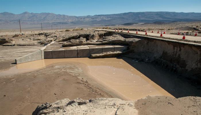
State Route 190 sustained much of the roadway damage inflicted by storms last year in and near Death Valley National Park.
District 9 photograph
The latest report describes several safety-related developments of note, including one in District 6. State Routes 33 and 180 cross paths in Mendota, one of the most disadvantaged communities in California. Caltrans worked with the city (which has a population slightly under 13,000) to improve and transform the highways in several ways.
The Caltrans-Mendota collaboration, which will extend for a few more years, began in earnest with a pavement-preservation project that allowed the reconfiguration of the travel lanes by removing one through lane in each direction and placing a center turn lane and Class II bike lanes. The new configuration reduces the number of conflict points for motorists, provides dedicated space for bicyclists, and enhances the safety of pedestrians by eliminating the “multiple threat” issue to pedestrians by having fewer through lanes to cross. Also, a marked crosswalk was installed based on input from residents.
Cultivating Excellence
Caltrans strives to provide quality services to all Californians and collaborate effectively with partners statewide, developing and supporting a skilled workforce committed to delivering excellent results.
In August and September of 2022, several heavy storms in the Death Valley National Park region caused devastating flooding and miles of roadway damage. Maintenance crews were immediately mobilized from around District 9 to assist with debris removal and shoulder repairs, and two emergency projects were initiated to address the pavement loss and undercutting on State Routes 163, 178 and 190.
Caltrans worked closely with its counterparts at the National Park Service, meeting frequently both in the field and virtually to coordinate on public messaging, timing of highway re-openings, and the operation of local escorts to aid in the safe movement of park staff, tribal members residing in the park, and residents of outlying communities.
Strengthen Stewardship and Efficiency
Caltrans continues to deliver on a “fix-it-first” philosophy to support the state’s aging infrastructure while efficiently maximizing the use of our limited transportation funding. Caltrans recognizes and applies asset management to drive socially equitable investment decisions as part of effective performance.
On U.S. Highway 199 near Crescent City in Del Norte County, District 1 completed culvert replacements including a fish-passage improvement. This project also included five culverts in Jedediah Smith Redwoods State Park and involved many partnerships with other state agencies. The trenchless approach installed at three locations boasts less environmental impact, contributes to fewer traffic delays, increases worker safety, and saves time and money.
Enhance and Connect the Multimodal Transportation Network
Caltrans works closely with its partner organizations to modernize and integrate transportation on services and improve connections among various modes of travel — all with the goal of improving the experience of those who use the system.
State Route 37, a 21-mile vital transportation link in the region connecting four North Bay counties in District 4, is extremely vulnerable to flood-related closures due to sea level rise and experiences a high level of congestion. Caltrans, the Metropolitan Transportation Commission and four North Bay Area Transportation Authorities are partners in the Resilient SR 37 program, which works on multiple studies addressing the corridor’s multiple issues.

Caltrans' stormwater public-education campaign is contributing to a cleaner California, especially in coastal areas.
Headquarters photograph
In December 2022, Caltrans completed a comprehensive, long-range Planning and Environmental Linkages (PEL) Study to identify the best solutions to address the diverse environmental and social needs of this complex corridor. The collaborative and integrated approach to transportation decision-making will inform project development for both near-term improvements and the final corridor plan.
Lead Climate Action
To address climate change, Caltrans works to mitigate contributing factors within its control (such as greenhouse gas emissions), create infrastructure that can sustain changing elements (such as earthquakes and wildfires), and lead by example with strategies that can be duplicated and adapted throughout the United States and globally,
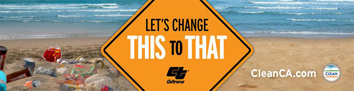
In 2022, Caltrans (led by Headquarters) and the California Coastal Commission formally joined forces for the first time during the 38th annual California Coastal Cleanup Day by expanding the typical single-day celebration into a month's worth of public cleanup and litter prevention events throughout September.
Caltrans' stormwater public education campaign, “Let’s Change This to That,” and the California Coastal Commission invited Californians to participate by cleaning up their neighborhoods, parks and especially areas adjacent to waterways. The effort was focused not only on the coastline but also along rivers, creeks and lakes. Trash from inland areas can flow downstream, so cleaning up neighborhoods can prevent litter and debris from ever reaching our vital waterways.
Advance Equity and Livability in All Communities
Caltrans endeavors to deliver outcomes that benefit all and eliminate disparities that have been created by transportation historically so that all people in California are able to achieve economic prosperity by way of a transportation system that allows them to get where they need to go safely, efficiently and with choice in mode.
Through its Clean California program, the District 12 Maintenance Division addresses all acute litter service gaps in underserved areas along Caltrans rights-of-way. Every quarter, state officials assess litter conditions along state highways, ranking litter found along highway locations as satisfactory, minor or acute. Prior to 2022, these assessments showed 35 one-mile highway segments with acute litter conditions in underserved communities in Orange County.
In 2022, the full-time deployment of three Caltrans litter crews and eight contractor litter crews – in addition to incentivized Adopt-a-Highway participation and four active litter maintenance agreements with local agencies – resulted in the virtual elimination of acute trash issues in disadvantaged areas along highway roadsides within District 12’s jurisdiction.
Source: The 2022 Caltrans Annual Accomplishments Report (pdf)
![]()
Project Spotlight: New bridges link to improved safety
District 5 photograph
Shoulders widened, seismic elements modernized on State Route 1 in San Luis Obispo County
Caltrans provided enhanced safety and modernized engineering this past June by completing a $17.9 million project to demolish and replace the Toro Creek Bridge on northbound State Route 1, north of Morro Bay in San Luis Obispo County.
The project included $16.3 million in funds generated by Senate Bill (SB) 1, the Road Repair and Accountability Act of 2017.
The shoulders of the old Toro Creek Bridge, which date from the early 1940s, did not allow for bicycle traffic to pass over the bridge without sharing the outside lane with traffic.
In addition to the nonstandard shoulder widths, structural and geotechnical investigations revealed that the bridge’s foundations were seismically deficient. Correcting this deficiency was required to accomplish the widened shoulders over the bridge. Replacing the bridge railing ensured compliance with what is specified in the Manual for Assessing Safety Hardware.
The old bridge measured approximately 130 feet long by 32 feet wide. It consisted of six spans, five piers and 35 supporting pile extensions. The new project created a wider three-span bridge, using fewer piers than the previous one. Eight new piles were installed in the creek channel. The inside shoulders now measure 5 feet wide and the two 12-foot-wide lanes now have a right side shoulder width of 10 feet.
The new bridge profile was slightly increased to accommodate the anticipated sea-level rise from climate change. The new abutments and installed rock slope protection (RSP) safeguards the abutments from erosion.
Construction began in May 2022 and included a traffic shift with one lane in each direction for travelers. Initially, the new configuration featured two lanes in the northbound direction with traffic flowing over the new bridge and one lane in the southbound direction. In early summer, a second southbound lane opened.
Caltrans landscape planners anticipate that the surrounding, newly planted vegetation will take about two years to attain a mature appearance.
J. Fabian Velasco, a Caltrans project engineer and structures representative out of the Goleta office, is hands-on involved with District 5 bridge projects.
District 5 photograph
The new bridge complies with current earthquake, geometric, hydraulic and structural standards and represents an important upgrade to the state transportation system’s infrastructure. The prime contractor was Souza Construction of San Luis Obispo.
Elsewhere in San Luis Obispo and also on State Route 1, Caltrans demolished and replaced the 82-year-old Old Creek Bridge near Cayucos. The project’s need was similar to the Toro Creek Bridge as original shoulders were insufficiently wide by today’s standards and the seismic engineering was outdated.
The $9.3 million Old Creek Bridge project was mostly funded by SB 1.
The new structure consists of a three-span bridge, supported by concrete columns at the piers (the original bridge had five spans and four piers founded on reinforced concrete pile extensions). Inside shoulders now measure 5 feet wide, and the two 12-foot-wide lanes now have a right shoulder width of 11 feet, 6 inches – which exceeds the 10 feet minimum.
Similar to the Toro Creek Bridge replacement, the bridge’s height was slightly increased to accommodate the anticipated sea-level rise.
Construction began this spring with a 24/7 closure of the northbound/ southbound number 1 (left) lane to install protective barriers for highway workers during the daytime hours, followed by a traffic switch where travelers headed northbound on Highway 1 were diverted onto the southbound lanes with two-way (north/south) traffic maintained with a center median.
This traffic switch allowed for the demolition of the bridge on northbound State Route 1.
Papich Construction of Arroyo Grande served as contractor for the project, which was completed this summer.
Sources: Carla Yu, District 5 senior transportation engineer and project manager for both the Toro Creek and Old Creek projects; and Jim Shivers, District 5 public information officer
![]()
Division Spotlight: TAM monitors Caltrans’ performance, goals
Caltrans photograph
Transportation Asset Management refreshes 10-year plan to address anticipated needs
Welcome to a new series that will continue in future issues of Mile Marker. These stories will examine, in a nuts-and-bolts way, a specific Caltrans program. We begin our series with Transportation Asset Management.
Perhaps as much as – if not more than – any program within Caltrans, Transportation Asset Management (TAM) takes a big-picture look at the department. TAM conducts analyses of transportation asset inventory, current condition and performance levels to objectively measure past performance and plot a clear-eyed course for the future.
The department’s website describes TAM as “a strategic and systematic process of operating, maintaining, upgrading and expanding physical assets effectively throughout their life cycle. It focuses on business and engineering practices for resource allocation and utilization, with the objective of better decision making based on quality information and well-defined objectives.
“Advancing Asset Management across an organization requires self-assessment, alignment, goal setting and support."
Caltrans is divided into 12 regional districts. Each one of these districts is unique in terms of environment and topography. “They have different inventory,” Johnson explains in the video. “Some have transportation assets that are newer, some have transportation assets that are older.
In April, TAM described itself in a more-detailed way by uploading a video on YouTube. Here are some of the presentation’s key points, as made by Michael B. Johnson, State Asset Management Engineer.
“We’ve got coastal communities, we’ve got mountainous communities, we’ve got desert communities. We have very affluent areas, we have very disadvantaged areas. So the state is very, very diverse.”
Because some of the districts are bigger than some smaller U.S. states, Caltrans decided that a “more granular performance-based asset-management plan was needed.”
At the top of Caltrans’ TAM approach is the California Transportation Asset Management Plan (TAMP). The document covers a 10-year period, and it is updated every four years. The most recent TAMP, which applies through the 2031-2032 fiscal year, is downloadable from this Caltrans webpage.
“In this plan,” Johnson says, “we are looking at portions of the Caltrans-owned highway system, but not all of it, and we’re looking at portions of the locally owned transportation system that is part of the national highway system.”
Local ownership of the National Highway System (NHS) is greater in California than in any other state. In terms of pavement, for example, 35 percent of the NHS is owned or managed by cities and counties and 65 percent by Caltrans. Bridges, conversely, are 90 percent owned by Caltrans and 10 percent by cities and counties.
There are four primary asset classes: Pavement and bridges (which are federal requirements), culverts and Transportation Management Systems (TMS) elements.
Below the TAMP in TAM’s approach is the State Highway System Management Plan (SHSMP), which includes 33 different performance objective areas. Those areas include matters related to asset condition such as pavement and bridges, but also safety performance, delays, climate resiliency and bicycle and pedestrian needs.
Analyses within SHSMP are done at the district level, which means that with all dozen districts taking stock on 33 areas, in total there are nearly 400 performance gap analyses.
Johnson explains that there are three types of performance models.
- The Physical asset model (dealing with inventory, its condition and predictable deterioration – “anything that you can go out into the field and touch with your hand,” Johnson says). Examples include pavement, bridges, drainage components, TMS plus also highway pump plants, overhead sign structures, roadside rest areas, buildings such as maintenance shops and laboratories.
- The deficiency model (non-condition-based issues such as safety, climate resiliency and stormwater.) “Safety itself is not a physical asset,” Johnson elaborates. “It doesn’t deteriorate. But we do know that we want to set targets for safety improvement, which is measured, in our case, by reducing fatal and serious injuries.”
- The reservation model. The winter of 2022-2023, an unrelenting parade of winter storms caused over $1 billion in damage to the state’s highway system. Caltrans “has to reserve some funding for things that we can’t predict” Johnson says. “We don’t know when they’re going to occur, and we don’t know where they’re going to occur, but history has shown us that they do occur. So we look at prior years’ expenditures in these areas to develop a reservation of funding that can be utilized throughout the year as these unpredictable things happen.” (Examples include earthquakes, fires and slides.)
To get the various analyses within TAM underway, Headquarters gives each of the 12 districts a specific set of performance goals, or preferred outcomes. They would include numbers such as how many fatal and serious injuries a district needs to reduce, how many lane miles of pavement it needs to rehabilitate, or how many square feet of poor-condition bridges it needs to rehabilitate or replace.
“We do this for all 33 objectives, and we give each of our District Directors a single budget to do that,” Johnson says. “Our districts then have to develop projects that achieve all that performance within the budget that’s defined. They have to live within a constrained budget. And if they do this, we are guaranteed that the projects that come forward will meet the performance objectives that were established.”
Caltrans video screenshot
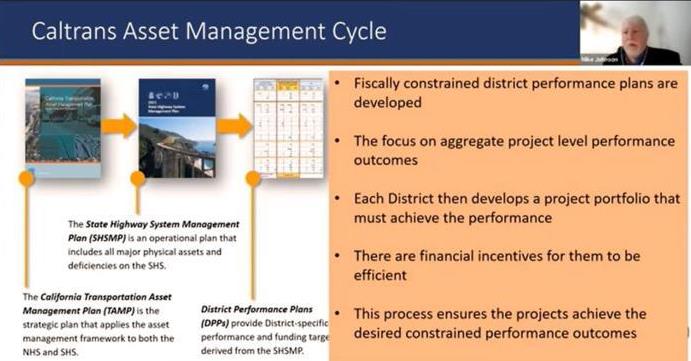
Following the TAMP and SHSMP, the Caltrans Asset Management Cycle proceeds to District Performance Plans (DPPs), which identify the inventory, current condition or performance levels, quantification of the pipelined performance, and targets for the last five years of the 10-year plan period and a target project portfolio budget.
The projects developed feed the State Highway Operations and Protection Program (SHOPP) 10-Year Project Book online dashboard. This public-facing dashboard (projectbook.dot.ca.gov), stemming from the DPPs, establishes a 10-year portfolio of projects to meet targets set forth in the TAMP and SHSMP. It is certified every quarter. The online format includes search and download functions that ease navigation for users.
The cycle continues with a four-year SHOPP project portfolio that goes to the California Transportation Commission (CTC) for authorization of funds. Finally, the Performance Benchmark Report is compiled and presented to the commission every June to track progress and provide transparency to the public.
“Risks are part of this performance-based approach,” Johnson says. “When we implemented this, the culture really shifted in Caltrans. I’ve been with the department for a long time, and I know, many years it was about, ‘Well, you have a budget. Did you spend your money?’ Nobody talks like that at Caltrans anymore. What they talk about is, ‘Did you achieve your performance?’ … Performance is in the front seat; budget is in the back seat.”
To sum up the overall role of Asset Management, Johnson says that TAM stresses transparency, encourages public input, pursues equity and incorporates community pride into projects.
Find out more by visiting TAM’s homepage.
Source: Michael B. Johnson, State Asset Management Engineer
![]()
Caltrans has a plan, literally, to make things safer
Caltrans Headquarters photograph
RSAP’s aspirational goal is to eliminate roadway deaths, serious injuries by 2050
This is the first year that Caltrans is implementing road safety actions identified in the biennial Road Safety Action Plan (RSAP) that enhances road safety for every traveler on California’s roadways.
The 2023-2024 RSAP is Caltrans’ roadmap to embedding the Safe System Approach in all its functions. It guides Caltrans in meeting its aspirational goal to eliminate all fatal and serious-injury crashes by 2050.
The RSAP provides a framework for realizing Caltrans’ safety vision. It advances the work that began with the creation of the Division of Safety Programs in 2020 and release in 2021 of the very first Director’s Policy on Road Safety (DP-36), which adopts the Safe System Approach.
To establish an RSAP process, Caltrans identified single points of contact or Safe System Leads (SSLs) within each district and major headquarters division. Together, 26 statewide SSLs identified 14 actions of statewide significance to focus on safe system outcomes in every stage of the project lifecycle including, planning, alternatives assessment, design, construction, operations and maintenance.
The actions included in the RSAP focus on reducing risks for all users, including those who drive, walk, ride or use other modes of transportation and therefore advance Caltrans’ goals of enhancing multimodal transportation, equity and livability in all communities.
The work of the RSAP is divided into four specific categories:
- Integration of safety into Caltrans policies
- Best safety practices
- Data collection and databases
- Public outreach
Caltrans photograph
The roots of the RSAP run deep and reflect Safe System best practices at the state, federal and global level.
The U.S. Department of Transportation in 2022 released a comprehensive National Roadway Safety Strategy matched by once-in-a-generation funding for safety advances nationally under the federal Infrastructure Investment and Jobs Act (IIJA), which was signed in 2021. The IIJA further embeds the Safe System Approach in traffic safety through integration with the various federally funded grants and programs. The California State Transportation Agency is one of the Allies in Action embracing the National Roadway Safety Strategy.
FHWA points out that “applying the Safe System approach involves anticipating human mistakes by designing and managing road infrastructure to keep the risk of a mistake low; and when a mistake leads to a crash, the impact on the human body doesn’t result in a fatality or serious injury. Road design and management should encourage safe speeds and manipulate appropriate crash angles to reduce injury severity.”
The Safe System approach is based on the following six principles at its core:
- Eliminate death and serious injury
- Responsibility is shared
- Redundancy is crucial
- Humans make mistakes
- Safety is proactive
- Humans are vulnerable and reactive
While the first RSAP covers actions to be completed in the years 2023-2024, this will be an ongoing effort with updates every two years. Caltrans will share the insights from this plan with the local agencies across the state to enable them to support the statewide road safety goals.
Traffic fatalities and injuries demand a broad-based and aggressive response. The systematic and coordinated efforts through RSAP create a strong policy framework for adopting the safe system approach over the next two years and help maintain a long-lasting focus on eliminating fatal and serious injuries by 2050.
Source: Shum Preston, Headquarters public information officer
![]()
EEOP celebrates, nurtures Caltrans well-rounded workforce
Archived video library helps employees learn more about diversity, equity and inclusion
“Modern” Caltrans was created in 1973, when the Division of Highways was formally reimagined and renamed as the California Department of Transportation.
During the 50 years that have followed, Caltrans’ work has evolved from automobile- and highway-centric to feature an ever-evolving focus on safety, efficiency and less-or non-polluting forms of multimodal transportation.
Caltrans’ workforce has changed, too. Diversity, equity and inclusion are increasingly pursued, achieved and – thanks in part to the department’s Equal Employment Opportunity Program (EEOP) – celebrated.
The EEOP is responsible for ensuring Caltrans complies with federal and state anti-discrimination laws and legal requirements in all of its internal business practices and activities. The EEOP additionally strives to carry out Caltrans' overall commitment to providing a workplace that recognizes the benefits of diversity and inclusion, and all individuals are treated with professionalism and respect.
Starting in mid-January with Martin Luther King Jr. Day and continuing through Transgender Remembrance Day just before Thanksgiving, every year the EEOP organizes or participates in a variety of gatherings, discussions and special events that provide Caltrans employees with opportunities to learn more about and to honor diversity, equity and inclusion.

EEOP video screenshot
Since 2020, the EEOP has kept an archive webpage on the internal Caltrans website that gives employees the chance to, at their leisure, watch video presentations by guest speakers, of roundtables composed of internal and external subject experts, and about other people and scenes relevant to whatever is being discussed. For example, early in 2023 the EEOP archived:
- "Moving Forward Together," a discussion by a Caltrans EEOP Black History Month panel.
- "What Black California Wants from Reparations,” a presentation by Ama Anane from Good Influence Consulting that was also part of Black History Month in February.
- “Radical Safety: How to Create Safer Spaces for Girls and Gender-Expansive Youth,” a Women’s History Month presentation by Chantal Hildebrand of Alliance for Girls.
- “Women Paving the Way to a Brighter Future,” a panel discussion with Luc Sou and Lima Saft that was also part of EEOP’s Women’s History Month activities in March.
Several other ethnic-and diversity-themed months followed, including:
Arab American Heritage Month (April). “Arab ethnicities are comprised of many cultures that share similar histories, language and practices,” EEOP says to Caltrans employees on their internal website. “Arab refers to someone who uses Arabic as their first language and comes from an Arab nation. It is also used to describe descendants of someone who fits these criteria. Although many Arabs are Muslim, not all are.”
Asian American and Pacific Islander Heritage Month (May). “Although these particular events are East Asian centered, this celebration encompasses a vast diversity of communities and ethnicities. AAPI includes East Asia, South Asia, Southeast Asia, Micronesia, Melanesia and Polynesia. This area ranges from India in the west to Easter Island in the east.”
Latino Heritage Month (mid-September to mid-October). “Formerly known as Hispanic Heritage Month, which only included people who spoke Spanish, Latino Heritage month includes those from a wide range of ethnicities that reside in or have ancestral ties to Latin America (Mexico, Central America, South America, and the Caribbean).”
EEOP also has archived special events and presentations related to LGBTQ+ Month (June) and National Disability Employment Awareness Month (October).
Learn more about Caltrans’ Equal Employment Opportunity Program by visiting its public-facing website.
Source: Shalinee Hunter, EEOP assistant director; and Tiffany McCallister, EEOP staff services manager II
![]()
QuickMap, the Caltrans app that gets better and better
Recent additions include tools for commercial vehicles and road closure push-notification options
“For the most current traffic and road closure info, turn to Quickmap.dot.ca.gov.”
That little statement from District 10, a region containing several Sierra Nevada highways that often close due to snowfall or rockslides, is a common suggestion shared by Caltrans public information officers (PIOs) when they are advising the public on how best to prepare for driving in inclement conditions.
For those who don’t know, Caltrans’ QuickMap is a mobile app and website available to the public at no cost for travel planning. QuickMap provides immediate traveler information, including traffic speed, lane and road closures due to construction and maintenance activities, emergency incidents, electronic highway message sign content, rest area locations and amenities available, CCTV camera snapshots, and active chain control requirements.
This real-time traveler information tool, overseen by the Division of Traffic Operations, has added a few new features. Last year, QuickMap was augmented with push notifications, and this summer it added a “Commercial Vehicles” option.
On June 29, Caltrans introduced the Commercial Vehicles layer via social media. Its features include truck weigh station locations and color-coded California truck networks. Here’s a primer on how to use this new function:
- Select "QuickMap Options."
- Select the "Commercial Vehicles" layer from the dropdown menu.
- Select "Truck Weigh Stations" to view the locations of statewide weigh stations. Uncheck to remove them from the map.
- Select "California Truck Networks" to view color-coded routes on the map. Uncheck to remove them from the map. Those colors represent National Network Route (green), Terminal Access Route (blue), California Legal Route (black), California Legal Advisory Route (yellow) and Special Restriction (red).
More features within the Commercial Vehicles layer are being pursued, and soon will go “live.” Those possible additions include data points about truck-escape ramps, truck service access and truck terminal access. Real-time wait times southbound at California-Mexico border crossings is information that has long been offered on QuickMap; the addition of northbound wait-time postings is still being developed.
In August 2022, Caltrans launched the push notification feature on its QuickMap app that allows all drivers to automatically receive real-time notifications about nearby road and rest area closures.
The push notification feature allows travelers to opt in to receive location-based alerts on their mobile devices. When a device with the QuickMap app enters an area within 10 miles of a road closure, a pop-up message will appear alerting travelers of the incident, including time, location and reason for closure.
Truckers can consult QuickMap to help determine the best route to take depending on evolving circumstances.
QuickMap screenshot
QuickMap is an increasingly helpful travel-planning tool for anyone driving in California. Caltrans PIOs continually encourage its use through media interviews and social-media posts. For example, District 9 is especially active in QuickMap promotion, as it contains the eastern portions of District 10 highways (including State Routes 4, 104 and 120) that cross the Sierra Nevada.
District 2, a North State region that encompasses many mountain roadways, also makes a point of plugging the app.
“We primarily promote QuickMap as the most reliable and up-to-date resource for roadway information in our district and state,” says Denise Yergenson, District 2’s chief PIO. “We also use QuickMap in our office as a resource for gathering current roadway information and accurate details to pass on to the traveling public through our social media outlets and callers to our district phone. QuickMap has proven to be a user-friendly resource that all can use while traveling through our district and throughout the state of California.”
Find out more about QuickMap on this Caltrans webpage, which contains a list to frequently asked questions about the app.
Caltrans reminds drivers to use their mobile device responsibly, including only in hands-free mode when operating a vehicle. Using your cell phone while driving is not only dangerous, but illegal. In California, drivers 18 and older can only use their phones in a hands-free manner, such as speaker phone or voice commands, but never while holding it.
Source: Division of Traffic Operations, Headquarters Public Affairs
![]()
Robot mowers lighten workload, increase safety
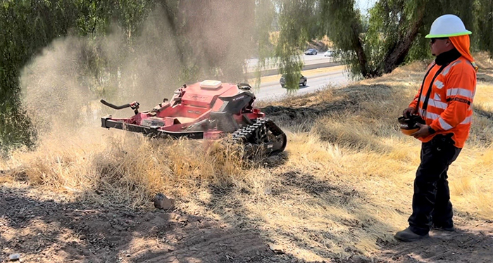
District 6 photograph
Remote-controlled machines tackle tight spots, help District 6 crews dodge dangers
Ever-evolving technology is helping to enhance efficiency and minimize roadside dangers for motorists and Caltrans landscaping crews. Robot mowers have made their way to various Caltrans districts and in the summer of 2023, they powered their way to District 6, which encompasses Fresno, Kern, Kings, Madera and Tulare counties.
With thousands of acres to maintain along California’s highways, Caltrans landscaping crews are tasked with a daunting amount of mowing and upkeep, in challenging conditions. The introduction of robot mowers has proven to be a game-changer.
A normal year’s workload combined with a precipitation-pounded winter like that of the 2022-2023 season equated to a substantial increase in what crews encountered along transportation corridors. District 6 enlisted the assistance of two remote-controlled mowers, more commonly known as robot mowers, to combat the growth while increasing the number of acres that could be landscaped in a workday.
Routine weed abatement on most of state right of way includes utilizing large-scale equipment to mow large flat areas, deploying multiple crew members armed with hand tools, or a combination of both. With the addition of the robot mower, crews can have the ideal combination of “small but mighty.”
Because of its mobility and dimensions, a robot mower can access areas that larger equipment may not be able to navigate. Its compact size in comparison to a large counterpart, however, is nothing to scoff at.
The robot mower can precisely cover a large amount of area with one operator controlling it, helping minimize how many crew members are needed for one task. By taking on the repetitive and labor-intensive task of mowing, these robots significantly reduce the workload of Caltrans crews, allowing them to focus on other essential maintenance activities.
These robot mowers are not just helping minimize workloads and increase efficiency. Their most prominent benefit is increased safety for crews.
Landscape maintenance alongside busy highways poses inherent risks for both motorists and Caltrans crews. Many California highways have steep embankments that require workers to mow and/or landscape by hand. Robot mowers can ascend and descend slopes and cover large areas, thereby drastically minimizing the need for manual labor.
Though robot mowers help reduce the amount of crew members needed to work in an area, staff are needed to help minimize the possibility of equipment striking an object that could result in a spark or fire igniting on state right of way. To help diminish the chances of this occurring, prior to working in the area, crews visually scan the area to identify potential hazards. This method is functional, but not infallible and because of this, crew members ensure that fire suppression equipment is present at all mowing operations and they are trained on proper usage.
Staff and supervisors recognize and appreciate that the use of these remote-controlled mowers helps minimize crews’ exposure to traffic, helps decrease trip and fall hazards, and increases the opportunity for steady footing for mowers’ operators.
The use of robot mowers and similar technology represents a move toward a more innovative, efficient and – most importantly – safer Caltrans that benefits our employees and the traveling public.
Source: Elizabeth Yelton, District 6 public information officer
![]()
Stormwater device brings Caltrans closer to statewide compliance

Division of Environmental Analysis graphic
Caltrans receives patent for a space-saving device that makes stormwater flow cleaner and require less maintenance
Trash and debris accumulate along roadsides and often then get carried into drainage systems with rainfall runoff. The refuse can end up in streams, rivers, or lakes, where it can adversely affect the use of those resources for humans, fish and wildlife.
Removal of garbage and debris from roadway runoff is a challenging problem for Caltrans. Until recently, the trash-capture systems that are available have had large footprints and required considerable right of way. Installing and operating them in urban and ultra-urban areas has posed many difficulties, including tricky access, high costs, disruptive construction and persistent maintenance issues.
Traditional trash-capture devices that can be installed in upstream locations such as drain or curb inlets are of limited use in highway environments due to potential flooding, hydroplaning, safety and maintenance-personnel exposure issues. There is a need for a trash-capture system that could be easily retrofitted in existing highway drainage infrastructure or included in newer projects. Such a system is designed to reduce frequency of maintenance and be easier to maintain without compromising safety of the travelling public.
To address this issue proactively, Caltrans Division of Environmental Analysis (DEA) initiated a trash-capture device development and testing project in early 2020. The DEA Stormwater staff Cornelis Hakim developed the initial idea for a “capture housing” device.
To address this issue proactively, Caltrans Division of Environmental Analysis (DEA) initiated a trash-capture device development and testing project in early 2020. The DEA Stormwater staff Cornelis Hakim developed the initial idea for a “capture housing” device.
Computational fluid dynamics modelling was used first to assess the feasibility and performance. Next the hydraulic capacity, trash-capture characteristics, operation and ease of maintenance was tested on a full-scale physical model. The test results helped guide development of several device configurations suitable for various field conditions. After the successful testing, Standard Plans and Design Guidance were developed. Caltrans also submitted an application to the U.S. Patent Office, and a patent for the innovative trash-capture device was granted in December.
The device is essentially a concrete structure that consists of two vaults. Vault 1 houses a screen weir that divides Vault 1 into a trash-capture approach/storage area and a bypass channel inlet. Vault 2 houses the trash-capture box (screen box) and bypass channel outlet.
The accompanying figure shows typical flow paths through the capture housing when it is in place – typically under a roadway curb’s storm grate. Rainfall runoff drains through the grates into the capture housing trash-storage area and screen box. The recommended flows up to 0.7 cubic feet per second for the 1year/ 1hour intensity are contained within the screened trash storage area. Larger storms are bypassed over the screen weir in the trash storage area, over the screen box.
The capture housing is designed so that all particles greater than or equal to 5 millimeters (0.197 inches) are captured within a stainless-steel screened trash-receiving area. The screen for the weir and trash box consists of uniformly spaced 4.8-millimeter openings that prevent particles larger than that from passing through. Untreated stormwater runoff enters Vault 1 either from top through the roadway grates, from an inlet pipe, or both. Roadway grates over Vault 2 mainly provide maintenance access and are also screened to smaller than 5 millimeters.
This innovation demonstrates Caltrans active and continuing commitment to initiatives that enhance California's natural environment. This device could help Caltrans to meet the 2030 statewide trash compliance and 2026 trash discharge Cease & Desist Order enforcement obligations.
Source: Bhaskar Joshi, supervising transportation engineer, Division of Environmental Analysis-Office of Stormwater Program and Development
![]()
Mileposts
Caltrans graphic
Mile Marker shares highlights from recent developments of note that predominantly involve Caltrans
Caltrans continues its clean-waterways quest
Caltrans, through its Stormwater Campaign “Let’s Change This to That,” partnered with the California Coastal Commission for the second year in a row to advocate for cleaner coastlines and pollutant-free water during September’s Coastal Cleanup Month.
Numerous cleanup activities – including ones in Huntington Beach, Sacramento and San Francisco – took place statewide throughout the month with a goal of preserving the natural splendor of California’s coastline and ensuring that both inland and coastal area residents understand their impact on community waterways, such as lakes, rivers, creeks, and the ocean.
During the first year of the partnership in 2022, the California Coastal Commission found that statewide volunteer participation on Coastal Cleanup Day was up nearly 25 percent. The partnership aims to build on that success and encourage even more Californians to join a cleanup effort.
Caltrans awards $41 million for sustainable projects
Powered by an infusion of state and federal investments, Caltrans awarded $41.6 million in planning grants for 90 sustainable, climate-resilient transportation projects throughout California that address local and regional impacts of extreme weather events fueled by climate change.
The projects selected will help reduce planet-warming pollution, improve resiliency of the state highway system, enhance access to safe walkways and bike paths, and increase natural disaster preparedness.
Nearly $30 million comes from one-time state and federal sources made possible by Gov. Gavin Newsom’s historic $15 billion clean transportation package in the 2022-23 state budget to further the state’s ambitious climate goals. Another $12.4 million comes from Senate Bill (SB) 1, the Road Repair and Accountability Act of 2017. The awards will fund project planning and conceptual design efforts, helping move the projects closer to construction. They include:
- $20.2 million in Sustainable Communities Competitive and Technical Grants to 56 local, regional, tribal and transit agencies for transportation and land use planning, as well as planning for electric vehicle charging infrastructure.
- $18.1 million in Climate Adaptation Planning Grants to 26 local, regional, tribal, and transit agencies to identify transportation-related climate vulnerabilities through the development of climate adaptation.
- $3.3 million in federally funded Strategic Partnership Grants to eight projects that will plan for comprehensive highway corridors, rural agriculture and highway safety, tourism demand, intercity bus systems, transit centers, and other sustainability initiatives.
Transportation infrastructure loses ‘high risk’ label
The California State Auditor removed the state’s transportation infrastructure from its “high-risk list” after 16 years in recognition of the progress California has made in rebuilding and upgrading the state transportation system in recent years.
The auditor first designated California’s deteriorating transportation infrastructure as a high-risk issue in May 2007, noting at the time that a long-term stable funding source was needed to address maintaining and upgrading the state’s aging roads and bridges, reduce traffic delays, improve goods movement, and increase options for transit, intercity rail and active transportation like walking and biking.
That all changed with the passage of Senate Bill (SB) 1, the Road Repair and Accountability Act of 2017, which provides more than $5 billion in transportation funding annually that is shared about equally between state and local agencies. SB 1 represented the first significant, stable and ongoing increase in state transportation funding in more than two decades. To date, California has invested nearly $20 billion in SB 1 funding in almost 14,000 projects in communities throughout the state, creating more than 254,000 jobs.
As the auditor notes, keeping California’s transportation infrastructure in good repair is important because it enhances safety and maintains the usable life of critical state assets, which currently consists of 50,000 lane miles of pavement, 13,200 bridges, 213,000 culverts and drainage facilities, and nearly 21,000 transportation management system elements (changeable message signs, meters, etc.).
Efforts to raise SR-37, restore habitat get federal boost
California’s efforts to ensure the long-term resiliency of State Route 37 (SR-37) and San Pablo Bay received a significant boost this summer with the infusion of $155 million in federal funding.
The California Transportation Commission formally allocated the funds to elevate a key section of State Route 37 to guard against future flooding on a vital regional corridor that connects Marin, Sonoma, Napa and Solano counties and enhance habitat connectivity for San Pablo Bay. The $180 million project will raise the roadway by 30 feet over Novato Creek by 2029, well above the projected year 2130 sea-level rise.
The $155 million allocation comes from the federal Infrastructure Investment and Jobs Act (IIJA) and is lauded by environmental groups and local leaders who have been calling for investments to support the long-term viability of the SR- 37.
The funding builds on a partnership agreement forged earlier this year among state and local agencies on a suite of commitments to implement near-term improvements to SR-37 while pursuing a long-term climate-resilient corridor that reestablishes habitat connectivity across San Pablo Bay.
The project reduces risks of route closures due to flooding and presents an opportunity to enhance bicycle and pedestrian access.

Caltrans graphic
State honors 11 Caltrans workers with Medal of Valor awards
The state of California honored 11 Caltrans employees with the Governor’s State Employee Medal of Valor, the highest honors California bestows on its public servants. The awards are given to state employees for acts of heroism that go beyond the normal call of duty and at great personal risk to protect state property or save lives.
Caltrans Landscape Maintenance Worker Brian Rubalcava and Highway Maintenance Worker Jason Lofton were awarded the Silver Medal of Valor for their heroic act during a dangerous rescue in extreme cold weather down steep terrain to save a couple after their vehicle went over a snow-covered embankment in Siskiyou County on Dec. 19, 2021.
Caltrans Equipment Operators Jeremy Maraviov, Scott Davidson and Trevor Gipson were awarded with the Silver Medal of Valor for saving a father and young son after their car went down a steep embankment in Trinity County on Dec. 26, 2021.
Caltrans Highway Maintenance Worker Nicholas Macias and Equipment Operator Robert Hernandez were awarded the Silver Medal of Valor for saving a man trapped inside a burning vehicle in Merced on Aug. 3, 2022.
Caltrans Equipment Operator Roberto Lopez was awarded the Gold Medal of Valor for rescuing a colleague who was trapped in a burning vehicle after an incident with a cargo truck in San Diego County on May 26, 2022.
Caltrans Maintenance Area Superintendent Cody Collins and Transportation Engineering Technician Jeffrey Scardine were awarded the Silver Medal of Valor for rescuing a student who fell while taking a bank scaling and rock-climbing course in Kingvale on Oct. 6, 2022. The student was dangling by rope, putting him into a life-threatening situation. Collins and Scardine quickly assessed the situation, rappelled, and transferred the student safely to the ground, saving his life.
Caltrans Highway Maintenance Worker William Miller was awarded the Silver Medal of Valor for rescuing a woman after her vehicle struck Miller’s in the early morning of Jan. 21, 2020, in Placer County. Despite his injuries, he selflessly saved the woman in the other vehicle before both vehicles were engulfed in flames.
The State Employee Medal of Valor award is the highest honor California bestows on its public servants. Governor Edmund G. Brown Sr. presented the first awards in 1959. Since then, more than 700 state employees, including 116 Caltrans employees, have earned the honor for their courage and selflessness in the face of danger.
Source: Division of Public Affairs
![]()
Mile Markers

Caltrans Strategic Plan Performance Objectives
Caltrans 2020-2024 Strategic Plan has a series of performance objectives meant to gauge success at affecting the intended outcomes for each of the six goals. This dashboard represents those performance objectives that we are tracking and are able to report on.
Goal: Safety First
Reduce the number of on-the-job serious injuries to zero, annually.

Goal: Cultivate Excellence
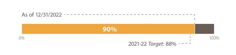
Increase the percentage of employees who take identified strategic training for the year, to 90% or more, annually.
Increase the percentage of Caltrans leaders at all levels who have been trained in Implicit Bias Training, by 70% by September 2022. This performance objective is now complete.

Goal: Multimodal
Caltrans is in the process of establishing a baseline and to begin reporting on the number of Caltrans Active Transportation Plan's location-based needs planned and constructed by programmed projects. The location-based needs provides information related to bicycle, sidewalk, and crossing needs. Initially the projected due date for this effort was March 2022 however statewide data was not available which caused delays. The updated timeline is 2024.
Goal: Strengthen Stewardship and Drive Efficiency
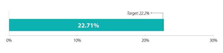
Increase the utilization of DBE certified contractors, overall and across each SED group, to annually achieve our DBE goal of 22.2%.
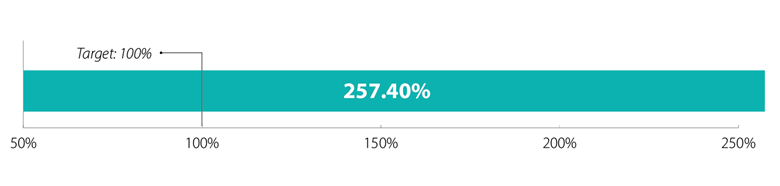
Increase the dollar value of small businesses, disabled veteran business enterprises, and disadvantaged business enterprises, by 100% by June 2024.
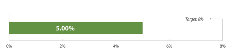
Goal: Lead Climate Action
Increase the percentage of Caltrans fleet that are ZEVs, to 8% by June 2023.